The title might seem rather obvious – or a surprising statement coming from me! But what I seek to achieve in this short blog post is provide a simple reminder that historically cold weather has indeed happened without a sudden stratospheric warming (or significant stratospheric polar vortex disruption).
The role of the stratosphere can sometimes be overstated. We saw in winter 2018-2019 how a major SSW doesn’t even necessarily spell dramatic cold weather for the UK since some stratospheric events do not couple strongly downwards. The state of the stratospheric vortex is a “boundary condition” to which the troposphere responds (to varying degrees). That’s what makes it so fantastic – we can gain predictive skill from it for several weeks. But it is not the only boundary condition.
However, for us in the UK on the receiving end of an “Atlantic radiator” of warmth, deep cold does need something significantly unusual to happen. A breakdown of the mean westerly circulation in the stratosphere can do that (as we saw in Feb-March 2018) but other drivers can provide similar impacts. The troposphere is a noisy place.
Figure 1 shows that the DJF-mean 10 hPa 60N zonal-mean zonal wind has only a weak relationship with the UK DJF mean precipitation (temperature even less so, but I’ve used rainfall here as it has no clear trend, and colder winters tend to be drier). It’s interesting that the very wettest winters have had a contemporaneously strong 10 hPa vortex, suggesting these are unlikely without stratospheric support – but that’s about as much as this shows. Evidently, strong vortex does not simply equal wetter and stormier.

Now time for a few case studies to illustrate the point…
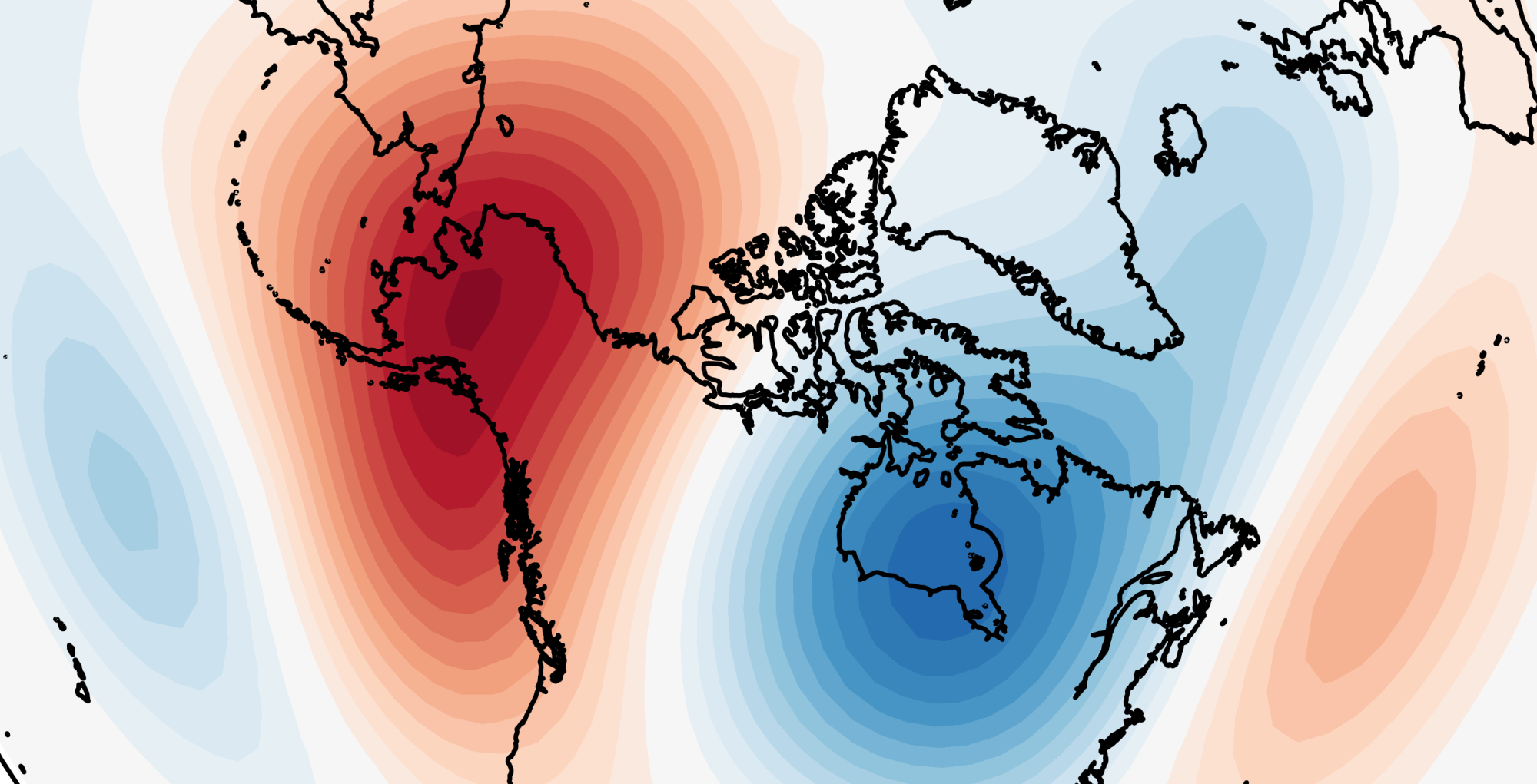
December 2010
With a mean Central England Temperature (CET) of -0.7C, December 2010 was the coldest December since 1890 and the first month with a mean CET below freezing since February 1986. It is the only recent winter month which comes anywhere near rivalling the “great winter” months (e.g. January 1963) that have become increasingly rare due to climate change. I often wonder how cold it might have been had it occurred 50 years earlier.
But, while the winter of 2009-2010 saw some of its cold weather associated with a major SSW on February 9th 2010, there was no major SSW in December 2010. In fact, the 10 hPa vortex was around average strength (Figure 2). There was no “dripping paint” from the stratosphere; the anomalous blocking/negative Arctic Oscillation pattern was confined to the troposphere (Figure 3).


Evidently December 2010 was extraordinary, so I’ll support this with another example…
January 1987
The easterly outbreak in January 1987 makes 2018 look like the Wimp from the East, and it was generally unrivalled until 2018’s Beast. Figure 4 shows the 850 hPa temperature field on 12 January 1987, when the cold wave was near peak intensity.

Some of you may recall there was a major SSW in January 1987, and you’d be correct – but it was on January 23rd, after the cold weather outbreak! In fact, the Scandinavian ridge that brought the cold wave in 1987 may have helped drive the SSW which followed. Lehtonen and Karpechko (2016) pointed out how the tropospheric patterns (blocking) associated with these severe cold waves can act as drivers of SSWs themselves, with the greatest cold preceding the stratospheric event but the best predictability following the event. Something similar may also have occurred in January 2010.
So, as we move into a period where the polar vortex looks to be strengthening – remember that there’s more to the UK winter than the stratosphere…
See what happens this year marked to be in-between cold and mild.
Dear Simon,
I follow you closely on Twitter and have started reading detail on this website too.
I did not see a contact email for you. So please excuse me messaging you in this manner.
I wondered whether it would be possible to send you an email to ask you a question about undertaking a meteorological degree?
Kind Regards,
Andrew Cohen
Hi Andrew – sure, simonhaydnlee@outlook.com 🙂